
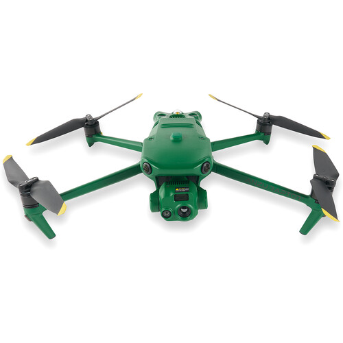
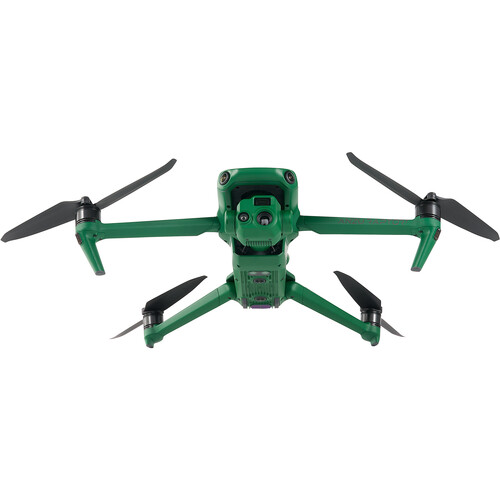


ANZU ROBOTICS Raptor T Overview
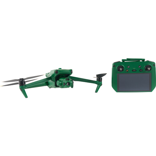
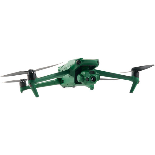
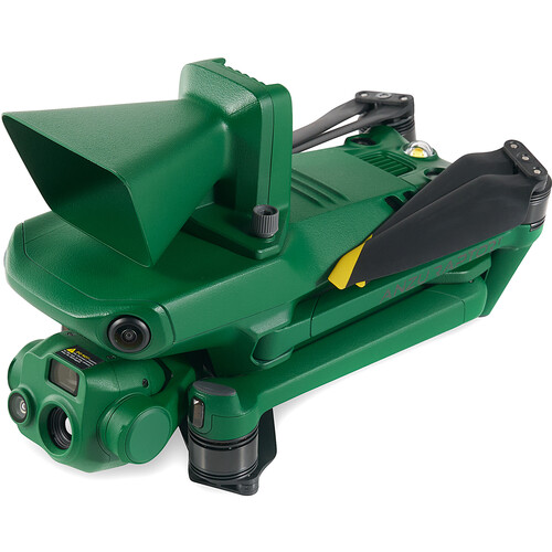
Designed to combine high-quality aerial imaging with robust data security, the Raptor T Enterprise Drone with Thermal Imaging from ANZU ROBOTICS delivers enterprise-level features supported by American-based systems. Based in Austin, Texas, Anzu Robotics partnered with American-based software developer Aloft, who created the apps used to control the Raptor T and store its data on US-based servers for optimal security. The Raptor T can capture this data using a triple camera system, featuring wide and telephoto lenses for up to 4K resolution at 30 fps, and thermal imaging at 640 x 512 resolution. In addition to visual and thermal imaging, the included RTK module allows the Raptor T to perform extremely accurate mapping. This powerful combination makes the Raptor T ideally suited for many industries and professions, such as first responders, agriculture, and surveying.
No Geofencing
Pilots can enjoy pure flying freedom when piloting the Raptor T. Gone are the restrictive built-in geofencing rules that other drones utilize. However, while Anzu Robotics supports a pilot's ability to fly almost anywhere, it is still the responsibility of the pilot to adhere to local and federal guidelines.
Additional Features
- Advanced omnidirectional obstacle avoidance
- Up to 45 minutes of flight time
- 56x Hybrid zoom
- Low-light camera mode
- Split screen and zoom on the remote
- Up to 9-mile transmission range
- Pilot and manage missions with Aloft Air Control mobile app
- Folding design
- Aloft is both ISO27001 and SOC Type II certified
EAN: 190021099050
ANZU ROBOTICS Raptor T Specs
Key Specs
| Maximum Horizontal Speed | 47 mph / 75.6 km/h |
| Maximum Flight Time | 45 Minutes |
| Number of Cameras | 3 |
| Camera System | Thermal Vanadium Oxide (VOX) Sensor with -4 to 932°F / -20 to 500°C Measurement Range (61° FoV) Wide 48 MP, 1/2"-Type CMOS Sensor with 24mm-Equivalent, f/2.8 Lens (84° FoV) |
| Maximum Video Resolution | Thermal Up to 512p at 30 fps Wide Up to UHD 4K at 30 fps Telephoto Up to UHD 4K at 30 fps |
| Sensing System | Omnidirectional |
| Control Method | Included Transmitter |
| Maximum Operating Distance | 9.3 Miles / 15 km |
| Mobile App Compatible | No |
| Weight | 2.0 lb / 920 g (With Propellers) 2.3 lb / 1050 g (Maximum for Takeoff) |
Performance
| Maximum Horizontal Speed | 47 mph / 75.6 km/h |
| Maximum Ascent Speed | 17.9 mph / 28.8 km/h |
| Maximum Descent Speed | 13.4 mph / 21.6 km/h |
| Maximum Wind Resistance | 26.8 mph / 43.1 km/h |
| Maximum Take-Off Altitude | 3.7 Miles / 6 km |
| Maximum Flight Time | 45 Minutes |
| Maximum Hover Time | 38 Minutes |
| Maximum Tilt Angle | 35° |
| Hovering Accuracy | Vision Positioning Vertical: ±0.3' / 0.1 m Horizontal: ±1.0' / 0.3 m RTK Vertical: ±0.3' / 0.1 m Horizontal: ±0.3' / 0.1 m GNSS Vertical: ±1.6' / 0.5 m High-Precision Positioning System Horizontal: ±1.6' / 0.5 m |
| Maximum Angular Velocity | 200°/s |
Aircraft
| Rotor Configuration | Quadcopter |
| Propeller Size | 9.4x5.3" |
| Remote ID | Yes |
| Built-In Video Light | No |
| Aircraft I/O | 1x USB-C (Service) |
| Operating Temperature | 14 to 104°F / -10 to 40°C |
Imaging
| Number of Cameras | 3 |
| Camera System | Thermal Vanadium Oxide (VOX) Sensor with -4 to 932°F / -20 to 500°C Measurement Range (61° FoV) Wide 48 MP, 1/2"-Type CMOS Sensor with 24mm-Equivalent, f/2.8 Lens (84° FoV) |
| Digital Zoom | Thermal 28x Telephoto 8 to 56x |
| Minimum Focus Distance | Thermal 16.4' / 5 m Wide 3.3' / 1 m Telephoto 9.8' / 3 m |
| ISO Sensitivity Range | Wide 100 to 25,600 Telephoto 100 to 25,600 |
| Shutter Speed | Wide 1/8000 to 8 Seconds (Photo/Video) Telephoto 1/8000 to 8 Seconds (Photo/Video) |
| Maximum Video Resolution | Thermal Up to 512p at 30 fps Wide Up to UHD 4K at 30 fps Telephoto Up to UHD 4K at 30 fps |
| Still Image Support | Wide Up to 48 MP (JPEG) Telephoto Up to 12 MP (JPEG) |
| Photo Modes | Interval, Single Shot |
| Media/Memory Card Slot | In Aircraft Body microSD/microSDHC/microSDXC (UHS-I) [512 GB Maximum / U3/V30 or Faster Recommended] In Remote/Transmitter microSD/microSDHC/microSDXC (UHS-I) [U3/V30 or Faster Recommended] |
| Internal Storage | In Remote/Transmitter 8 GB |
Gimbal
| Number of Axes | 3: Pitch (Tilt), Roll, Yaw (Pan) |
| Rotation Range | Mechanical Range Yaw (Pan): 54° (-27 to 27°) Pitch (Tilt): 180° (-135 to 45°) Roll: 90° (-45 to 45°) |
| Follow Speed | Tilt: 100°/s |
| Stabilization Accuracy | ±0.007° |
Avoidance/Sensing System
| Sensing System | Omnidirectional |
| Sensing System Capabilities | Forward Measurement Range: 1.6 to 65.6' / 0.5 to 20 m Detection Range: 1.6 to 656.2' / 0.5 to 200 m Max Speed: 33.6 mph / 15 m/s Field of View: 90° (Horizontal) / 103° (Vertical) Backward Measurement Range: 1.6 to 52.5' / 0.5 to 16 m Max Speed: 26.8 mph / 12 m/s Field of View: 90° (Horizontal) / 103° (Vertical) Lateral Measurement Range: 1.6 to 82.0' / 0.5 to 25 m Max Speed: 33.6 mph / 15 m/s Field of View: 90° (Horizontal) / 85° (Vertical) Upward Measurement Range: 0.7 to 32.8' / 0.2 to 10 m Max Speed: 13.4 mph / 6 m/s Field of View: 100° (Front-to-Back) / 90° (Side-to-Side) Downward Measurement Range: 1.0 to 59.1' / 0.3 to 18 m Max Speed: 13.4 mph / 6 m/s Field of View: 130° (Front-to-Back) / 160° (Side-to-Side) |
Remote Controller / Transmitter
| Control Method | Included Transmitter |
| Operating Frequency | 2.4 GHz (2.400 to 2.484) 5.8 GHz (5.725 to 5.850) |
| Maximum Operating Distance | 9.3 Miles / 15 km |
| Transmitter Power | 2.4 G: 33 dBm (FCC), 20 dBm (CE, MIC, SRRC) 5.8 G: 33 dBm (FCC), 23 dBm (SRRC), 14 dBm (CE) |
| Transmitter I/O | 1x USB-C (Data, Power) 1x Mini-HDMI (Video) |
| Clean Video Output | No |
| Battery Type | Built-In Lithium-Ion (5000 mAh) |
| Wi-Fi | Wi-Fi 6 (802.11ax); Tri-Band (2.4, 5, & 6 GHz) with MU-MIMO Support (2 x 2) |
| Bluetooth | 5.1 |
| Mobile App Compatible | No |
| Built-In Display | 5.5" (1920 x 1080) Touchscreen LCD, 1000 nits/ cd/m2 |
| Operating Temperature | 14 to 104°F / -10 to 40°C |
Flight Battery
| Battery Chemistry | Lithium-Ion Polymer (LiPo) |
| Battery Capacity | 5000 mAh / 77 Wh |
| Battery Configuration | 4 S / 15.4 V |
| Maximum Charging Power | 17.6 V |
| Charging Temperature | 41 to 104°F / 5 to 40°C |
| Weight | 11.8 oz / 335.5 g |
Charger
| Charger Input Power | 100 to 240 VAC, 50 / 60 Hz at 2.5 A |
| Power Rating | 100 W |
General
| GNSS Support | GPS, GLONASS, BeiDou, Galileo |
| Diagonal Size | 15" / 380.1 mm |
| Overall Dimensions | 3.8 x 3.6 x 8.7" / 96.3 x 90.3 x 221.0 mm (Folded) 11.1 x 4.2 x 13.7" / 283.0 x 107.7 x 347.5 mm (Unfolded) |
| Weight | 2.0 lb / 920 g (With Propellers) 2.3 lb / 1050 g (Maximum for Takeoff) |
Packaging Info
| Package Weight | 11.59 lb |
| Box Dimensions (LxWxH) | 17.8 x 15.3 x 9.4" |
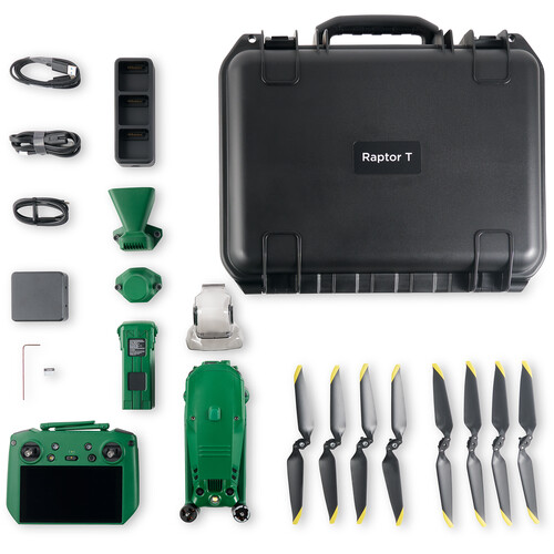
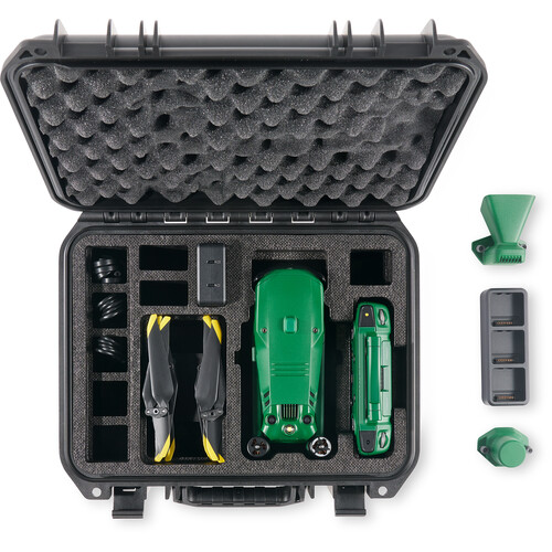
In the Box
- ANZU ROBOTICS Raptor T Enterprise Drone with Thermal Imaging
- Remote Controller
- RTK Module
- Flight Battery
- 2-Year Manufacturer Warranty
No posts found


